Morrison County Land Services Online Permits
App. Status: Approved
Valid: 09/24/2024 - 09/24/2026Morrison County Land Services
Morrison County Government Center
213 1st Avenue SE
Little Falls, MN 56345
320-632-0170
Project Location
| Parcel Associated with this project: |
|
| Property zoned as: | Shoreland (SR) |
| Type of road that accesses the property: |
County |
| Does the property have an address? |
Yes |
| Existing Septic System on the property? |
Yes |
 [
]
[ Search Result Limit:
[
]
[ Search Result Limit: Project Information
| ACUB? | Yes |
| Please check all that apply: | Dwelling Unit Addition Septic System |
| Please describe the project: | To construct a 25'x23' dwelling addition and a 15 x 15' screen porch To install a 1500 gallon two compartment tank with a 10 x 25 pressure bed. Conditions: 1. EROSION and SEDIMENT CONTROL a. Adequate temporary erosion and sediment control features shall be installed to prevent erosion and the loss of sediment to surface waters, wetlands, public ditches, and neighboring properties. Prior to exposing any soil, temporary perimeter controls, such as silt fence shall be installed downslope of the project area. Temporary control features shall be maintained until permanent stabilization. Vegetation shall be established on all exposed soils within 3 days of project end or pause. b. No new retaining walls are permitted within this permit. c. Any fill placed in the road right of way or new access points from the road needs approval from the road authority prior to filling. 2. STORMWATER CONTROL a. This project shall not increase the volume or velocity or course of stormwater entering neighboring properties in such a way that will cause negative impacts. b. Vegetative and topographic alterations necessary for construction are allowed within 15ft of the (EDGE, EAVE, WALL). Excavation, filling, or vegetative alterations outside of this area may require additional permitting. Contact the Planning and Zoning Office with additional grading or filling requirements. |
| Building Contractor: | BC688325 - KN Builders Inc. |
| Estimated Value: | $190,000.00 |
| Estimated Completion Date: | 04/30/2025 |
Project Details
| What is the square footage of the new dwelling addition? | 800 ft2 |
Setbacks: Property Lines
| From Road Right-Of-Way: | 193 Feet | Right Side Property Line: | 31 Feet | Left Side Property Line: | 40 Feet | Rear Property Line: | 97 Feet |
| Height of the structure: | 22 Feet |
Setbacks: Other
| How Far From A Feedlot? | 2000 Feet |
| Setback From Ordinary High Water Mark: | 150 Feet |
| Setback From Top Of A Bluff: | 150 Feet |
| Setback From Wetland: | 100 Feet |
| Is your project located within floodplain? | No |
Setbacks: Septic System
| Distance to the Existing Septic Tank: | 10 Feet |
| Distance to the Existing Septic Drainfield: | 20 Feet |
Attach Site Plan
| Attach a copy of your Site Sketch: |
|
| Date site will be staked: | 09/10/2024 |
 30481_septic_design.pdf
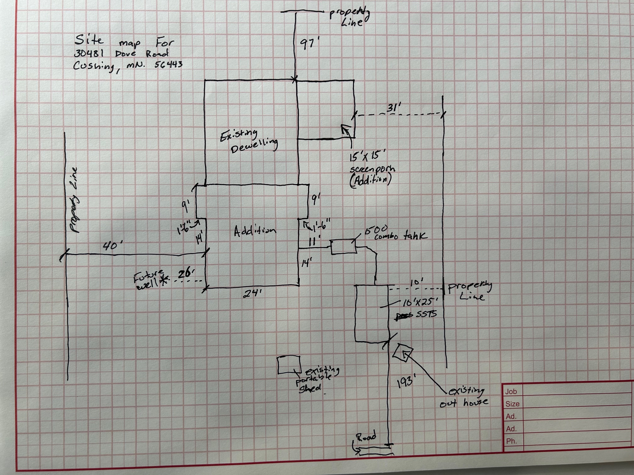
Terms
SHORELAND (SR) - Min. Lot Size: Pg. 67 (NE, GD, RD & Riparian vs. Non-Riparian Lots)
Minimum Distance From Side Property Line .......................................................... 10 Feet
Minimum Distance from State or County Road ....................................................... 50 Feet from R.O.W.
Minimum Distance from Township Road ................................................................. 30 Feet from R.O.W.
Setback From Top of a Bluff ....................................................................................... 30 Feet
Setback From Rear Property Line (No Lakeshore) ............................................... 35 Feet
Maximum Principal Structure Height ........................................................................ 30 Feet High
Maximum Accessory Structure Height & Size ......................................................... 18 Feet High / 1300 sq ft size
Minimum Distance from General Development Lakes .......................................... 75 Feet from OHW
Minimum Distance from Recreational Development Lakes ................................ 100 Feet from OHW
Minimum Distance from Natural Environment Lakes ........................................... 150 Feet from OHW
Minimum Distance from Forested and Transition Rivers ..................................... 150 Feet from OHW
Minimum Distance from Agriculture, Urban, and Tributary Rivers ...................... 100 Feet from OHW
Minimum Distance from Protected Wetlands ........................................................... 75 Feet from OHW
FEATURE____TANK AREA_____SEPTIC DRAINFIELD
Sandpoint Well / Shallow (less than 50' deep)......................50' .......................... 100'
Deep Well (more than 50' deep)...............................................50' .............................50'
Buildings........................................................................................10' .............................20'
Property Lines / Road Right-of-Way.........................................10' .............................10'
OHWM of: Gen. Dev. & Rec. Dev. Lakes and Streams.......100' .......................... 100'
Natural Environment Lakes and Rivers................................150' .......................... 150'
Mississippi River.......................................................................125' .......................... 125'
Section 604.12 of the Morrison County Land Use Control Ordinance states that every land use permit for a dwelling or addition to a dwelling in the ACUB overlay district surrounding Camp Ripley, the applicant shall sign a land use notification form.
- The land on which the selling exists or will exist is in an area that does have periodic noise impacts from military maneuvers and training exercises.
- The use of land within Camp Ripley and its ambient noise may adversely affect the residential use of the property.
- The ACUB notification will be on file in the Morrison County Planning & Zoning Office.
Invoice #10261 (09/10/2024)
| Charge | Cost | Quantity | Total |
|---|---|---|---|
| added 09/10/2024 11:52 AM $.25 Per Sq Ft. |
$0.20 | x 572 | $114.40 |
| added 09/10/2024 11:52 AM $250 |
$225.00 | x 1 | $225.00 |
| Grand Total | |||
| Total | $339.40 | ||
| Payment 09/10/2024 | $339.40 | ||
| Due | $0.00 | ||
Approvals
| Approval | Signature | Options |
|---|---|---|
| Applicant | KEVIN NOVAK - 09/10/2024 12:04 PM 850bfd8a28004323b9fc9d4d9b14f49b 09c67d8391a891f62aa76bab4771f36f | |
| #1 Preliminary Office Approval | Darrin Welle - 09/23/2024 9:35 AM 39387dc39fc4475137118889cea5d642 d6fe98cc190a34ce0ff57b640650c9f5 | |
| #2 Site Inspected By P & Z Staff | Darrin Welle - 09/24/2024 8:22 AM 772a19dc1d79a72c067fd8bbedb82e79 a4d2c1b184c415906fa8c254d47a5937 | |
| #3 Morrison County Planning & Zoning | Amy Kowalzek - 09/24/2024 10:00 AM 5d7213d6e68a5374c28bed90b12947c6 1e54b59312c4f1c238ea8a3d53cea845 |
| Text: | |
| File(s): |
|