Morrison County Land Services Online Permits
A) Land Use Permits Land-Use/Septic System Permit Permit # Z-2023-3235, App. # Z-App-5951, UID # 10224
App. Status: Approved
Valid: 09/06/2023 - 09/05/2025Morrison County Land Services
Morrison County Government Center
213 1st Avenue SE
Little Falls, MN 56345
320-632-0170
App. Status: Approved
Valid: 09/06/2023 - 09/05/2025Morrison County Land Services
Morrison County Government Center
213 1st Avenue SE
Little Falls, MN 56345
320-632-0170
Project Location
| Parcel Associated with this project: |
|
| Property zoned as: | Agriculture (AG) |
| Is your lot conforming? | Yes |
| Type of road that accesses the property: |
Township |
| Does the property have an address? |
Yes |
| Existing Septic System on the property? |
No |
 [
]
[ Search Result Limit:
[
]
[ Search Result Limit: Applicant
| Applicant Information: |
|
||||||||||||||||||||||||||||||||||||
| Contractor: |
|
||||||||||||||||||||||||||||||||||||
Project Information
| ACUB? | No |
| Please check all that apply: | New Barn or Barn Addition |
| Please describe the project: | 36'X48' pole shed with 12' side walls, 8' of the shed will be raised to 16' side walls to accommodate a loft. there will be a 12'X36' lean too on the gable end. the shed will have one 12'x10' siding door on the eve side as well as two 4'x8'sliding doors and a walk-in door going into the lean. Shed not be used as living quarters of any kind. There will be water on site for the animal(s), though building will not be plumbed. It will be tapped from a 42' wide strip to the south that is outside the boundaries of the covenant restrictions and piped to the site. |
| Building Contractor: | Jackson Held |
| Estimated Value: | $60,000.00 |
| Estimated Completion Date: | 10/22/2023 |
| Do you have building plans? | No |
Number of Structures
| How many barns? | 1 |
Project Details
| What is the square footage of the new barn or addition to an existing barn? | 2160 ft2 |
Setbacks: Property Lines
| From Road Right-Of-Way: | 800 Feet | Right Side Property Line: | 600 Feet | Left Side Property Line: | 500 Feet | Rear Property Line: | 1000 Feet |
Setbacks: Other
| How Far From A Feedlot? | 0 Feet |
| Setback From Ordinary High Water Mark: | 0 Feet |
| Setback From Top Of A Bluff: | 0 Feet |
| Setback From Wetland: | 50 Feet |
| Is your project located within floodplain? | No |
Attach Site Plan
| Attach a copy of your Site Sketch: |
|
| Date site will be staked: | 08/19/2023 |

Terms
Required Setbacks
AGRICULTURE (AG) - Min. Lot Size = 1 Acre / 150' Width
Minimum Setback from Side Property Lines: 25 Feet
Minimum Setback from Rear Property Lines: 35 Feet
Minimum Setback from Road Right-of-Way: 40 Feet
Animal Holding Area: Side & Rear Property Line Setbacks: 200 Feet
Non-Feedlot Animal Holding Area Side & Rear Property Line Setback: 50 Feet[url=http://www.co.morrison.mn.us/vertical/Sites/%7BC8FCCAFF-AECD-45DC-91B1-016A998EB4A8%7D/uploads/Setback_Requirements.pdf]View Setbacks[/url]
Invoice #8969 (08/17/2023)
| Charge | Cost | Quantity | Total |
|---|---|---|---|
| added 08/17/2023 5:48 PM $.10 Per Sq Ft. |
$0.08 | x 2,160 | $172.80 |
| Grand Total | |||
| Total | $172.80 | ||
| Payment 08/17/2023 | $172.80 | ||
| Due | $0.00 | ||
Action: Print
Approvals
| Approval | Signature | Options |
|---|---|---|
| Applicant | Jackson Held - 08/17/2023 5:50 PM ab3b878e5adc1c5afb574e53b8e88209 6107a711834c1967a5d3e541768025ef | |
| #1 Preliminary Office Approval | Sharon Peterson - 08/21/2023 1:16 PM af6097bc3b2028c1335f21ddd6017209 06afa6ae0ec773ffe21ddc2d8dc71637 | |
| #2 Site Inspected By P & Z Staff | Hannah Kruse - 08/31/2023 4:26 PM 358cdae5b712062b3de6ca63bca61b1e 56654602cedce641e86fcd035bab2e25 | |
| #3 Morrison County Planning & Zoning | Amy Kowalzek - 09/06/2023 9:31 AM 9f8465ebf3e3b74297de8a9945d15693 4f5860b703454afdfcc843475f6469d1 |
Application has been approved. All signatures have been obtained.
| Text: | |
| File(s): |
| Text: | Site visited 8/31/2023. Staked site is 50' from a Type 6 wetland. Setbacks are met. A covenant exists for this parcel that limits where residential structures can be placed and where water can be drawn from. The proposed site is within the approved building boundaries. The water plan George described to us (outlined in description above) is also in line with the covenant, as there is a southern boundary to the "South Property" from which they are allowed to draw water. See "Hohmann_south line" for the line drawn by Laura D from the metes and bounds description within the covenant. HK |
| File(s): |
|
 Hohmann_covenant.pdf
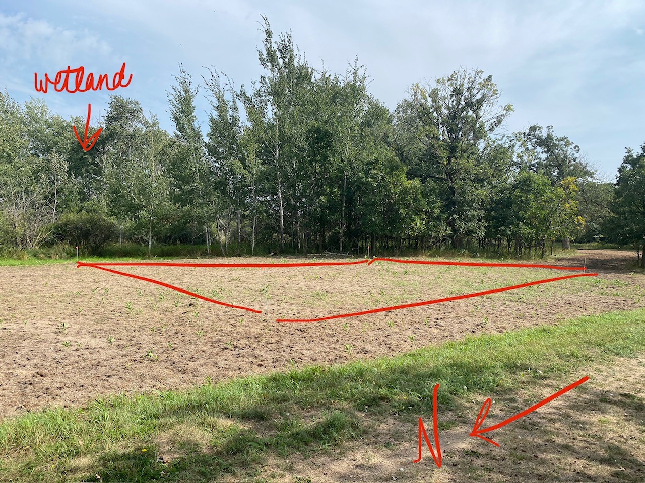
Set a start date for this application on the final approval.
| Start Date of Permit: | 09/06/2023 |